 Surface explorations were conducted on Tell el-Far'ah (South) in 1998 (map
ref. 1007/0770). The work was directed on behalf of the Ben-Gurion University
by Gunnar Lehmann and Claremont Graduate University by Tammi Schneider. The
project aims at re-studying the site, which was excavated previously by W.M.F. Petrie in 1928 and 1929.
Since then the field of archaeology has changed so much that the previous
excavations and report are somewhat outdated.
Surface explorations were conducted on Tell el-Far'ah (South) in 1998 (map
ref. 1007/0770). The work was directed on behalf of the Ben-Gurion University
by Gunnar Lehmann and Claremont Graduate University by Tammi Schneider. The
project aims at re-studying the site, which was excavated previously by W.M.F. Petrie in 1928 and 1929.
Since then the field of archaeology has changed so much that the previous
excavations and report are somewhat outdated.
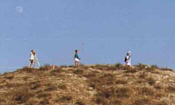
In December 1998 the site was mapped and an intensive surface survey
was conducted. The methods of the intensive survey reflect the approaches
of Charels Redman and Patty Jo Watson (1970), Robert Whallon (1979, 1980)
and Yuval Portugali (1982), being similar to the "Shovel-Test-Sampling" method
(Krakker et al. 1983). The methodology aims at determining variations in
size of settlements on tell sites and identifying the most efficient locations
on the surface of the tell for later excavation. With the use of a Theomat,
or computerized land survey equipment, data pertaining to the x, y, and z
coordinates of particular points on the tell were collected.
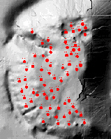 This data was then inserted into a digital cartographic mapping program,
Surfer being the specific program used for this project. Following this intensive
mapping of the site, more than 70 collection units were identified over the
entire tell surface. Units consisted of 3 meter diameter circles whose central
point of origin had been measured and documented (the x, y and z elements)
via the use of the Theomat. From these units all indicative artifacts were
collected, pottery being the most widely represented. An excavation of the
top soil, as suggested by Portugali (1982) was excluded because of the nature
of the survey license. Once the analysis of these artifacts had been completed,
the information and their corresponding time periods were inserted into a
computer database created by Prof. Jim Bently of Withrop University. Prof.
Bently then re-analyzed this information within the Surfer Program, allowing
him to generate and display frequency distribution maps of potsherds from
the various periods in which the tell was occupied. This ability to visually
observe the distribution patterns permitted dig directors to estimate the
extent of occupation within specific settlement periods, aiding in the location
of future excavation areas.
This data was then inserted into a digital cartographic mapping program,
Surfer being the specific program used for this project. Following this intensive
mapping of the site, more than 70 collection units were identified over the
entire tell surface. Units consisted of 3 meter diameter circles whose central
point of origin had been measured and documented (the x, y and z elements)
via the use of the Theomat. From these units all indicative artifacts were
collected, pottery being the most widely represented. An excavation of the
top soil, as suggested by Portugali (1982) was excluded because of the nature
of the survey license. Once the analysis of these artifacts had been completed,
the information and their corresponding time periods were inserted into a
computer database created by Prof. Jim Bently of Withrop University. Prof.
Bently then re-analyzed this information within the Surfer Program, allowing
him to generate and display frequency distribution maps of potsherds from
the various periods in which the tell was occupied. This ability to visually
observe the distribution patterns permitted dig directors to estimate the
extent of occupation within specific settlement periods, aiding in the location
of future excavation areas.
The results of this survey, according to specific collection area,
can be reviewed here.
|